Gardens of Earth Exploring Biophilic Design at the Scale of a City
Gardens of Earth explores biophilic city design through connected infrastructure, canopy water budgets and planted structures, with real world precedents.
Published October 31, 2026Analysis / Biourbanism / Sustainable Infrastructure
Publisher’s Essay / Design Analysis
Disclosure: Eric Storm is the author of Gardens of Earth and the publisher of JetsonsAge. He has a financial interest in sales of the books. This essay examines the design proposals alongside established practice and identifies the evidence needed to develop them.
Getting around the city is central to Gardens of Earth. Its proposed transportation matrix gives walking and mobility aids priority in streets and public spaces, extends neighborhood travel through cycling and small vehicles, and assigns larger passenger flows to buses and rail. Neighborhoods would be redesigned around those connections, with public routes and first-and-last-mile access planned alongside water, planting and service infrastructure. A protected crossing or a bus lane could improve an everyday journey while the surrounding district continues to evolve.
The aim is a gradual reduction in automobile use as convenient alternatives become reliable and individual sites become available for redevelopment. The books propose designing the next use of a transport corridor before removing existing capacity, while keeping occasional vehicle use practical. Their longer-term Metro Hopper concept would require further development, testing and approval. For residents, the nearer-term change would come through neighborhoods organized around accessible local journeys and dependable public transport, with less space committed to routine private-car storage.
The Infrastructure Beneath the Greenery
Thirty cubic meters of saturated growing medium can weigh 48 metric tonnes. In Gardens of Earth, that calculation appears beneath a far more inviting proposition: bringing trees, water and planted public spaces into the structure of a city.
The weight matters. A tree placed above a street needs room for its roots, a reliable water supply and a structure capable of carrying the load through changing weather and, in an earthquake region, shaking ground. The garden and the engineering occupy the same space.
That relationship runs through Storm’s two-volume work, now available in Kindle editions, with Volume I also available in paperback. Its city-scale proposals ask readers to consider buildings, transport, urban forests and water systems together. The images are expansive. The most useful questions emerge at a smaller scale: how much water would an added canopy require, what would hold its roots, and how would a city know whether the installation was performing as intended?
Three ideas offer a way into the books. The first is to treat urban infrastructure as a connected system. The second is to give vegetation the same quantitative attention as concrete and pipes. The third is to make the system’s performance observable, so that a promising drawing can develop into a testable proposition.
From a garden view to an urban system
Biophilic design begins with the human experience of nature in the built environment. Terrapin Bright Green’s 14+ Patterns of Biophilic Design organizes ways of thinking about that relationship, from the presence of natural elements to spatial qualities that shape how a place feels. It offers designers a framework for asking how buildings and public spaces might support human well-being.
Biourbanism reaches toward a different scale. The International Society of Biourbanism’s definition treats the city as a complex system whose interacting layers shape life within it. The two approaches overlap, but their questions differ. A biophilic room concerns the experience of its occupants; a systems-oriented urban proposal also asks where water comes from, how people move and who maintains the connections.
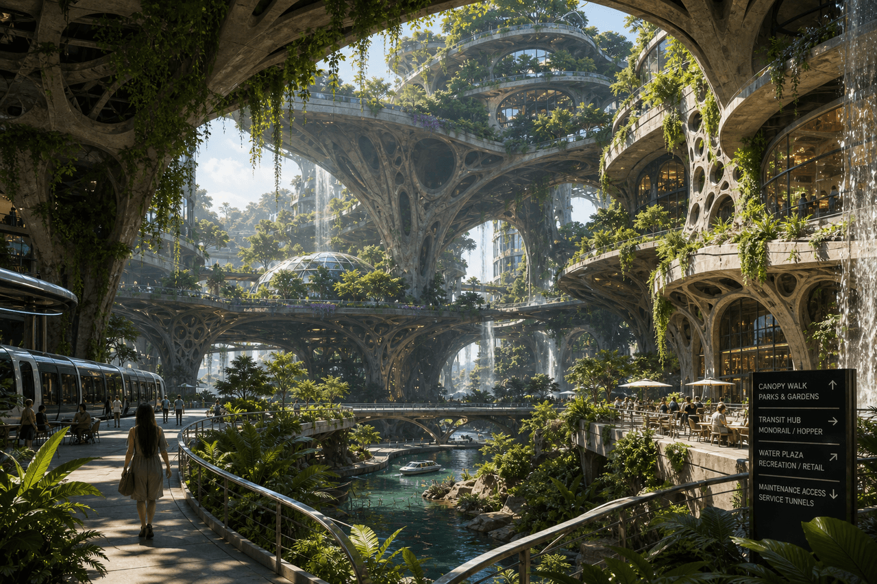
Gardens of Earth works across that boundary. Its visual language places planted terraces, shaded routes and waterways close to everyday movement. Its engineering passages then ask what those landscapes demand of the city beneath them. In those passages, planting volumes and water requirements become quantities that a pilot could test.
There are established precedents for combining these functions. At Singapore’s Bishan-Ang Mo Kio Park, the national water agency PUB and the National Parks Board transformed a concrete canal into a naturalized river. PUB describes a floodplain design in which the adjacent park helps convey water during storms. Plants, rocks and civil engineering work together along the banks. Approximately 10 bioengineering techniques underwent 11 months of testing before installation.
New York City offers a more distributed example. Its Department of Environmental Protection reports thousands of green infrastructure installations that intercept runoff from paved surfaces, helping reduce the water entering sewers and the burden on local waterways. Here, the relevant unit can be a street installation rather than an entire new district.
Those examples establish practical points of comparison. Singapore demonstrates how a public landscape can share space with a water-management function. New York demonstrates implementation across many sites within an existing city. The more ambitious structures pictured in Gardens of Earth would require their own engineering, operating budgets and public decisions.
The water behind the canopy
A citywide tree target can sound simple when expressed as a percentage. The book’s Los Angeles scenario makes the accompanying demand visible.
In Volume II, Chapter 34, the illustrative water ledger assumes a planning area of 250,000 acres and an existing canopy covering 21 percent. Raising that share to 35 percent adds 35,000 acres of canopy. At the book’s assumed annual demand factor of 1.74 acre-feet per additional canopy-acre, the increase corresponds to 60,900 acre-feet of gross annual water demand.
An acre-foot is the volume needed to cover an acre one foot deep. In this calculation, multiplying area by an assumed water requirement makes the scale of the commitment easier to examine. The book expressly treats the planning boundary, baseline and demand factor as assumptions requiring mapped and hydrologic verification.
Choosing the lower 32 percent target yields 47,850 acre-feet of additional annual demand. The 40 percent scenario yields 82,650. These figures describe a sensitivity exercise: a larger canopy carries a larger water requirement under the selected assumptions. Species, climate, soil conditions and establishment needs would shape an actual planting program.
Gross tree-water demand and irrigation delivered through pipes belong in separate accounts. Rain falling into the root zone can meet part of plant demand. Stored runoff may provide another supply. Irrigation losses, salt management and dry-year reserves can increase the amount a utility must deliver. Recycled water would count as a supply only after its availability, quality and allocation had been established.
The geography needs equally careful treatment. The books also discuss a 105-square-mile strategic infrastructure network, equivalent to 67,200 acres. That network and the 250,000-acre canopy planning area represent different boundaries. Keeping them separate lets a reader ask which neighborhoods receive investment, which land supports additional trees and which water systems would serve them.
For residents, those distinctions translate into practical choices. A city might prioritize a walking route exposed to afternoon sun, a school campus or a neighborhood with room for connected planting beds. The value of a larger canopy would have to be considered alongside reliable water service, access and the recurring work of keeping trees alive.
What the roots would require
The books’ root-cell discussion shifts attention from the visible crown to the volume below it. Volume I offers planning references of roughly 17, 28 and 42 cubic meters for different tree sizes, with actual design depending on species and site. A separate worked example in Chapter 21 uses 30 cubic meters and an assumed saturated bulk density of 1,600 kilograms per cubic meter to produce the 48-tonne mass.
That is a mass inventory, not a structural approval. The growing medium’s saturated density already includes its water. An engineering assessment would also address the container, tree, drainage arrangement and other loads, together with how forces reach the supporting structure and foundation.
This is where the economics of a planted building can diverge from those of planting at ground level. Elevated growing areas introduce structural support, waterproofing, inspection and replacement access. The design team would need to price those requirements alongside the public space or shade being created. At a suitable ground-level site, a simpler planting arrangement may answer the same community need with fewer construction interfaces.
The useful comparison is therefore between alternatives that provide a defined service. For a shaded pedestrian route, that might include ground-planted trees, conventional shade structures and an elevated planted system. A credible budget would carry capital work, water and energy use, maintenance labor and eventual replacement through the same planning period. The books’ illustrative quantities provide starting inputs for that exercise; local designs and supplier estimates would establish the costs.
A short pilot before a large commitment
Volume I, Chapter 25, proposes a canal-edge pilot with a planning allowance of 60 to 120 meters. Its dimensions would depend on the research question, available site, budget and maintenance arrangements. The proposal remains at the planning stage, with funding, institutional participation and construction subject to future decisions.
A modest installation could make several questions concrete. Investigators could measure water entering and leaving a planting area, document the condition of the growing medium and record the labor required to inspect and maintain it. Nearby comparison areas and observations across seasons would help distinguish the installation’s effects from changes in weather.
Singapore’s testing period offers a useful precedent for this sequence: investigate materials and techniques before extending them across a public landscape. The European Commission’s green infrastructure framework likewise emphasizes connected land and water spaces, often called blue-green infrastructure, managed for ecological and public benefits. The practical task is to identify which benefits a particular site can deliver and how those outcomes will be checked.
Nature-based solutions also come with responsibilities to the people living around them. The IUCN Global Standard provides a framework for designing and assessing interventions. For a Gardens of Earth pilot, a sensible public discussion would include who gains access to the space, who bears maintenance costs and how residents can influence later expansion.
Making the assumptions visible
The books connect their larger ambitions to a proposed Gaia Earth Simulator research program. Its relevance here is the possibility of testing linked urban systems and making their assumptions inspectable. A validated model of the proposed Los Angeles system remains a research objective.
The public Gardens of Earth Systems Explorer takes on a narrower task. Readers can adjust canopy area and the assumed water-demand factor, then see how those choices change the annual demand calculation. A separate root-media calculation shows how volume and saturated density determine mass. Each output retains its units and distinguishes a book assumption from a user-selected value.
Illustrative scenario explorer
Explore canopy, water and root-media assumptions
Adjust the book assumptions to explore annual gross plant demand and saturated growing-media mass. These educational scenarios do not predict net irrigation, cooling or structural capacity.
That approach gives the public a way to interrogate the proposal. A reader could choose a smaller planting target, test a different demand factor or ask why a proposed root volume carries a particular mass. More consequential predictions, including local temperature changes or long-term water savings, would require additional models and measured evidence.
The publication of Gardens of Earth gives these ideas a form readers can examine and debate. Its strongest invitation is to consider the connections usually divided among separate projects and budgets, then ask what a carefully observed first installation could establish. A city-scale vision becomes more useful when its next step is specific enough to measure.
Readers can explore the project and its two volumes at Gardens of Earth, where current editions and purchase options are listed.
Sources · 8
- https://www.terrapinbrightgreen.com/report/14-patterns/
- https://www.biourbanism.org/biourbanism-definition/
- https://www.pub.gov.sg/Public/Places-of-Interest/Our-Reservoirs-and-Waterways/Bishan-Ang-Mo-Kio-Park
- https://www.nyc.gov/site/dep/water/green-infrastructure.page
- https://environment.ec.europa.eu/topics/nature-and-biodiversity/green-infrastructure_en
- https://iucn.org/our-work/topic/iucn-global-standard-nature-based-solutions
- https://gardens-of-earth-systems-explorer.ready-rhino-9443.chatgpt.site/
- https://gardensofearth.com/books